

|
|
This is turning into one weird thunderstorm season, if you had of asked me several days ago I would have said it was the worst I've ever seen since I became interested in this subject, however after much thought I'm really beginning to change my mind simply because the few events I have seen have been severe or spectacular in one respect or another so it's been a case of quality rather than quantity, we also have only been getting marginal set-ups this year with low end CAPE, however incredible events continue to occur despite these limitations which really have underscored the low CAPE-high shear environments as the 'ones to watch'.
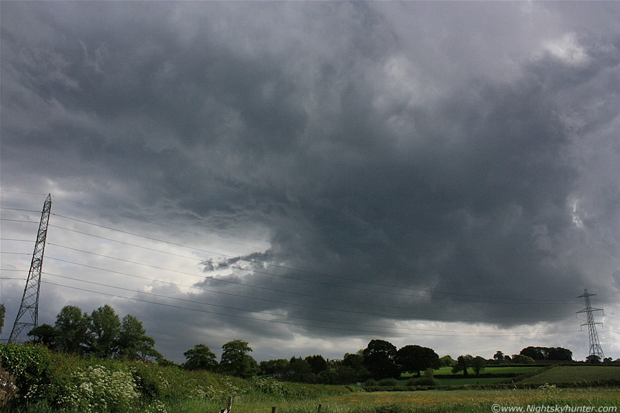
Saturday June 5th was another marginal day, the forecast was for scattered heavy showers with a low risk of thunder in a mild unstable SWly flow with general CAPE over NI being 100-200 with an enhanced area during the evening in SE Ulster with 400-500. There were no actual convective outlooks issued for here however UKASF had placed us in the 'watch' area. Conor McDonald and I had been watching GFS for several days and noticed the potential for Sat and for some reason we had a good feeling about it, at best though we thought we could get some nice convective images with a low risk of a funnel somewhere, but not much else. Sometimes you just know by looking at the sky if the day is going to produce or not. I was up at 11.00 after a late night watching for NLCs and by 12.00 I was more than a little impressed by the convection I was seeing to my W over the Sperrins, in that direction where lines of well developed towering cumulus with dark low level bases which looked very healthy indeed, so much so in fact that I had a very rushed breakfast then jumped in the car and parked up at an old favourite watch position on Glenshane looking to the W. I spent easily 2.5 hours in that one spot because I was amazed by what I was seeing.
To my W where very large towering cu in strong lines with long dark bases which were rotating like mad, I actually saw one cell with three well defined areas of rotation at the same time, many of these passed directly over my car so I had a splendid view as they spun and swirled straight above my head, this experience was repeated over and over again the entire time I was there from each new cell which developed, some of the rotation was so strong that some would have called them funnels. To put them in perspective I would say they had motion 1/4 speed of the tornadic-speed vortex we saw on April 29th, and that's without any exaggeration. I gave Conor a very excited call on the mobile and he confirmed he could see rotation on the sat images. From studying the sky over Glenshane it was obvious that there was significant convergence taking place over N. Ireland, the main flow and cells came from the W at that time, however I could see cloud racing in from the E and meeting the flow where it began to spin and grow in intensity - classic convergence zone in action. Convergence zones are regions where different airflows meet, the most common being when a Sea breeze moves over land and meets the inland flow, the area where they 'converge' is the perfect place for storm development as well as funnel clouds and CZ tornadoes.
I drove back home at 15.30 and sat out in the garden for a while since it was such a warm humid day with a bright Sun, so I thought I would catch some rays while reading Richard Dawkins excellent new book 'The Greatest Show On Earth' with a nice cold drink. After a little while I got up from my chair and glanced to the E and was shocked to see a huge cb taking up the entire E to SE horizon with an obvious wispy top, this was the first anvil top I had seen all day. I rang Conor again and he was on the situation straight away, he said he could see it on SAT24 easily with the anvil about three times the size of Lough Neagh, further more he noted what appeared to be an overshooting top, which I could actually see visually from Maghera, this was amazing since the cell was many miles away to the SE of NI on the E side of the Lough, we reckoned someone was getting a great show in that direction, we considered chasing it but we knew the cell would be over the Irish Sea before we got there, however it was an encouraging sign indeed and we decided that if anything else developed then we would be chasing that evening. It's a good job we didn't chase the cell because it died out and it never produced a single sferic anyway.
After this things went very quiet, the convection was dying and we considered the possibility that this was going to be another bust day. This was something we were, quite frankly, sick of. It felt like a life time since we last seen a storm and every situation since then had come to nothing, it seemed this Spring was full of let down's and downgrades, we were feeling so storm starved and desperate that we even just wanted to see a strong tower but for weeks it never happened with any intent, to tell you the truth we were close to giving up any hope on this season, of course we didn't have a clue what was going to happen a few hours into the future!
By 16.00 convection was developing once again to our W so things began to look up. By 17.00 I was in the town of Maghera doing some messages when I spotted a stunning cell tens of miles away to the S on the E side of Slieve Gallion, the updraught on this cell was the strongest and tallest I had seen all year and I immediately began to get excited, from it's position it looked to be near the Lough Neagh region so I rang Conor once again since I couldn't see the radar. He was watching the very same cell and was equally impressed with it, radar showed nothing but the Sat showed strong convection going up in that direction with more cells over the border to the SW heading NE so it was game on, we decided to chase asap.
I sacrificed my dinner and drove straight to Conor's home where we had one last look at the SAT, there were anvils and updraught towers approaching and we figured Lough Neagh would be a great place to intercept them, so we hit the road. It felt great to be back in action, both of us in the car with camera gear at the ready and blazing warm Sun above us as we headed SE on the hunt for storms, we were really buzzing and focused on coming home with a digital trophy of some kind. While on the main road we realised we had forgotten something so we had to turn around and head back home again. By the time we where back on the same stretch of road again we began to get concerned, we let out a nervous laugh because the sky had turned rubbish with all the convection dying out and breaking into strato cu, I didn't say it out loud at the time but I came very close to turning around and going back home and calling it a day, however our instincts wouldn't let go so we continued on our pursuit.
We reached the Castledawson roundabout, took the L turn onto the road to Antrim/Belfast then took a R turn which lead us onto beautiful country roads with fantastic scenery. Our plan was to head to Ballyronan Marina on the NW shore of Lough Neagh as a base then take things from there, however it didn't take long before we had the cameras out before this.
 |
As we drove along that scenic country road we noticed that the sky to the SW was getting darker and darker with more substantial convection on view, and the closer we got the more impressive it became. This cell loomed in the sky dominating the windscreen and we had to get a shot of it. I spotted an open gate on the RHS and drove into a field with the car wheels sliding to a stop on the dusty entrance. This was approx 1 mile NE of the Marina looking SW at this huge cell, it's dark colour contrasted beautifully with the rich green fields and yellow flowers and it felt fantastic to be standing among them in the heat gazing upwards at this thing. The cell was extremely large and dark with a shape like the classic Black Smith's anvil with sloping shape to the L and R high overhead. The base was weak however it had good structure, note the inflow cloud to the LHS moving into the central region, there was great lifting motion under the base too.
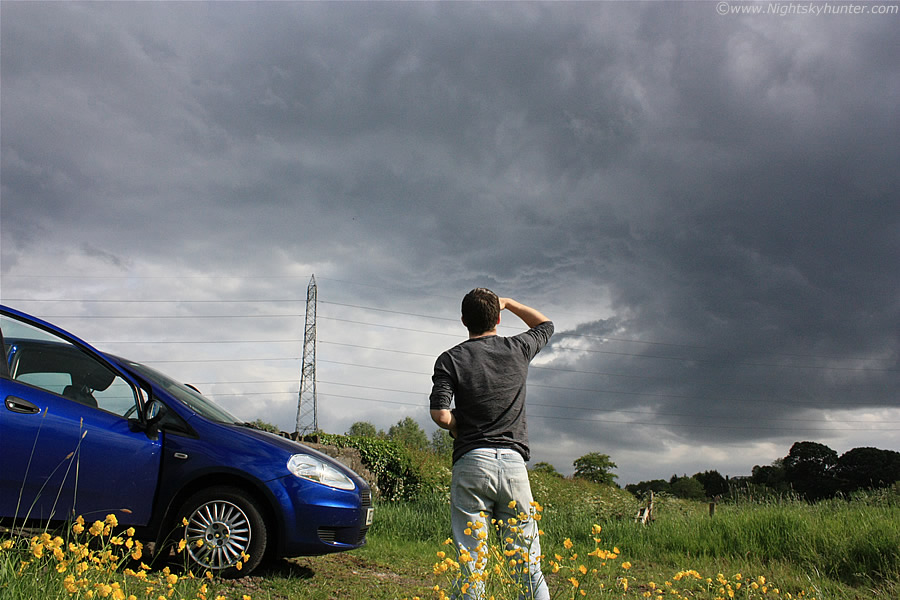 |
There's Conor enjoying the view, I was getting bitten by midgets while kneeling among the flowers for this shot, I like it because this was a natural shot as Conor was completely unaware I had taken it. The detail under the anvil plume to the upper L was quite impressive, not like mammatus, more like upside-down convection which looked quite remarkable with the naked eye. There was another large cell with strong updraught visible to the W (R) which got my attention for a while, I was half tempted to go after it however we decided to stick to our plan so we got back on the road and continued SE passing directly below that strange structure.
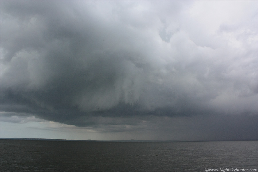
We eventually made it to Ballyronan Marina and pulled into the car park, we could see that the sky was VERY dark away to the S of the Lough but we didn't have a good view from the NW shore so we went back on the road again and headed S along the side of the Lough in the hope of finding a good vantage point to stop. The further S we drove the more astonished we became as more and more of that dark sky came into view, at first it was a large dark haze, then a long dark precip curtain could be seen along with remarkable cloud structure. We were really in the zone listening to 90's dance music while driving along the roads with the countryside showing of it's rich colours, it was relaxing, Cows chewed grass, Birds chirped, and Bees buzzed, life was peaceful and great.
That atmosphere changed in an instant, the scene to our LHS as the view towards the Lough bobbed and weaved between blurred trees was fantastic, this was not convection, this was a storm, and a big one too!. The radio was turned off in an instant and our attention was drawn to the storm like a magnet, this was one of those times when you just know you have something spectacular in view and that realisation takes about 1 sec to get the message to your brain, then suddenly your heart speed increases and you feel the sudden rush as that thrilling sensation takes over your body. This was a great moment for us because the radar was showing nothing at this time, no sferics either, so we pretty much got here by instincts and visual spotting alone, and they had paid off, there was a major storm cell over the water and we had to get positioned in the correct place asap.
 |
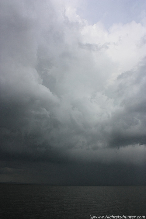
We where outside the town of Ardboe heading S so we needed to find an option to the E which would take us to the shore, a narrow country road beckoned and we took it, the road was blocked for a while then we managed to get through while dodging tractors with silage trailers which left us with very little room on the road. We sensed we where getting closer to the Lough but our view was blocked by tall trees, after half a mile or so the road curved to the L and ended beside a farmer's house, unbelievable, it was a dead end, and it wasn't even sign posted either, this made me slightly agitated since we wasted valuable time, in the distance those storm clouds were thick with weird motion and I dreaded the thought of missing a funnel so we quickly did a u-turn and returned to the main.
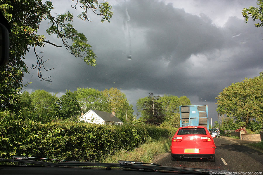
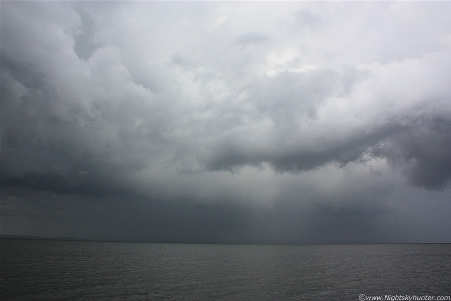
After this we just navigated by sight, ignoring road signs, and just instinctively selected the correct roads to get to our target, we were quickly on a roll and made up for lost time. We got held up by another tractor, then a herd of Cattle crossed the road so we had to wait for a few min's, this was when I took the above image showing the back of the storm through the windscreen, precip was falling then, the drops were very large and heavy, some were lit so brightly by the Sun that they looked like large hail falling through the air. You can see the large updraught base in the sky, that was the solid inflow region of the storm, and it was already rotating!, we couldn't wait to get stopped.
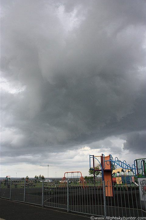 |
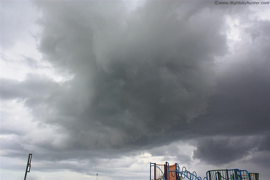
We found the perfect location at the Battery Harbour on the W shore of the Lough complete with car park so we pulled over feeling thankful at last to be at the scene. The view through the window was nothing short of spectacular, a huge solid updraught base was rotating directly over us with fabulous motion while overhead there was obvious convergence where two regions of cloud merged in a swirling motion. It was still raining at the time, I gave Conor my camera and he took this image through the open passenger window which was better protected from the rain. Check out the large precip drops (possible hail) falling in streaks through the air above the Children's play area. The actual precip curtain was over the Lough itself so this stuff must have been dropping over us from the rotating winds aloft since this was the inflow region.
 |
The precip eased and we at last could get out from the car and use the cameras, this is looking directly up into the updraught region where a large solid mass of cloud rotated in an anti-clockwise direction, you can even see that motion on this still image. The entire storm was of huge size and much to big to fit into the 18mm frame, this is only a portion of the entire cell, the rest of it was away to the R and into the distance straight ahead over the water.
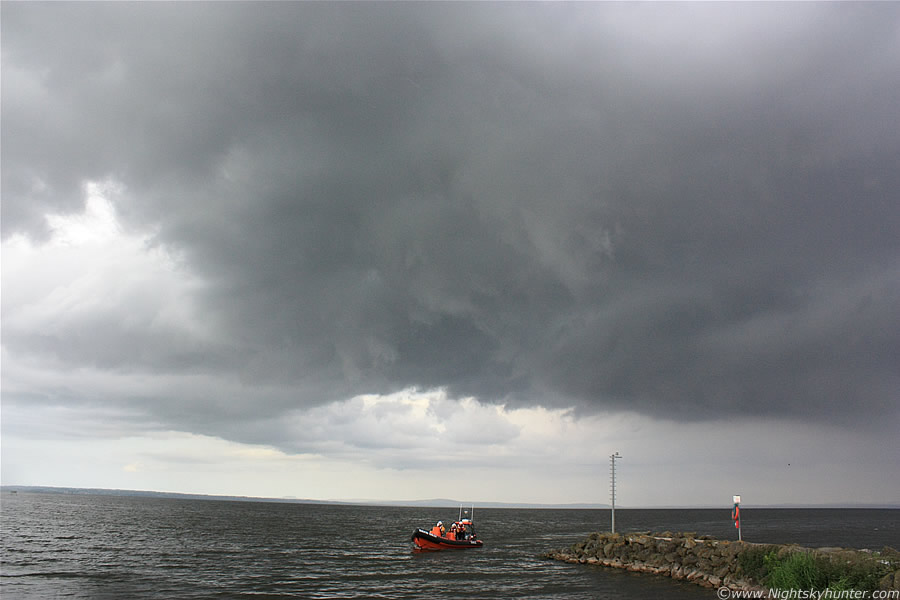 |
We walked down to the shore of the Lough for a better view, the Lough Neagh rescue boat had just arrived back from a call out and I quickly took this shot of the boat with thunderstorm above, the guys onboard shouted across to us and asked if we got any images of the them, then to send them over to their facebook page, we obliged, and they have them now. It was then that we began to realise that this was no ordinary thunderstorm, the structure was quite phenomenal. For instance, look at the clearance behind the cell, possibly air rushing down from the rotating updraught generating that clear slot, something not to dissimilar to a 'Rear Flank Downdraught' or RFD. Also, that row of cumulus clouds in the distance is an inflow band which we could clearly see feeding into the cell from R to L.
 |
There's Conor shooting the mid section of the cell at the inflow-outflow interface, the outflow area actually extends far out of frame to the RHS with part of the rotating inflow region to the LHS above the end of the pier. Believe me it was quite a sight to see that area rotating on such a large scale with the lighter grey coloured clouds getting sucked upwards and around continuously.
 |
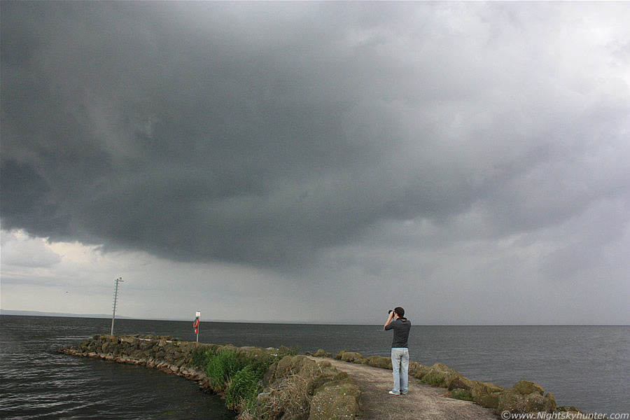
Conor and I then stood at the very edge of that rock pier which allowed us a stunning view of the storm, we where on the W side looking E to SE where the cell was, updraught to the L and downdraught to the R. Earlier on the sat images the cells where moving NE, however this guy had a mind of his own and didn't obey the flow and seemed to defy the rules. It was very difficult to shoot this storm because of the great dynamic range in brightness, the tops catching the Sun where brilliant white, or intense grey, the mid section darker grey, and base was extremely dark, and it kept getting darker with time. The precip area intensified as we watched and bright curtains of hail could be seen falling over the Lough, it looked quite nasty over there. Couple of Seagulls visible to the far L.
 |
This was when things began to get really interesting, first of, just to clarify, the storm was so large that we couldn't fit it in the wide angle 18mm frame, so these images only show one portion of the bigger picture. In the above image is the fantastic inflow/updraught base which was located on the L (N) side of the storm with outflow/downdraught region out of frame to the R (S) side of the storm, so keep this in mind when viewing the images. This entire area in the shot was rotating in a major way with the dark cloud base to the R moving across the Lough from R to L, the solid portion of cell closer to the camera was moving L to R (both like a conveyor belt) and these met on the LHS where they wrapped around in that lowered region, this motion was fast and continuous the entire time we where here. It was shocking to see such large scale rapid rotation on a day like this, the rotating area was over 50% of the entire length of the storm. You can see solid cloud structure wrapping around the updraught at the top of the frame from L to R forming a thick striation band. The light-coloured 'scud' tags where all individually rotating, before this shot was taken we seen a brief funnel at centre which didn't last long. This was how we ended up at the bottom of the pier in a rush.
 |
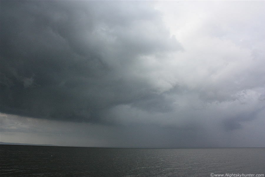
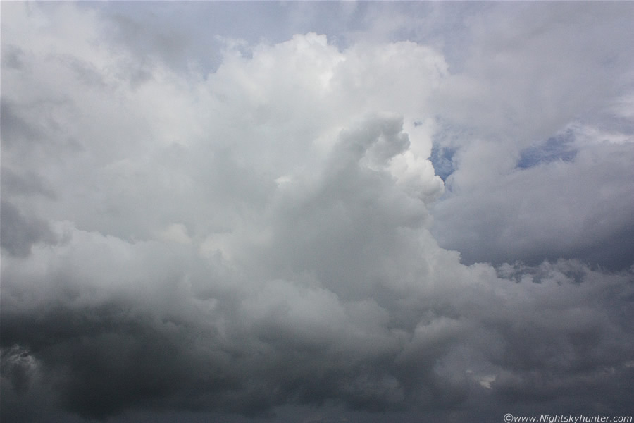
Camera panned to the R (S) at the outflow/precip region where a heavy precip core of rain and hail was busy doing it's thing. The radar at this time was showing strong red echoes. I won't even begin to describe the height of this cell yet, but in a nut shell it had the wow factor. Some mid level cloud was blowing across the Lough from our side heading towards the cell which partially obstructed the view, the Sun is catching young towers going up in that region, these fresh updraughts would become huge very soon. It was nice and warm standing beside the Lough with just a gentle breeze, it was quite surreal to see such a nasty dark storm structure on such a pleasant evening with Seagulls flying across the water catching the Sun. Conor and I were in full 'combat mode' at this stage, we were completely engrossed by the storm, there was so much happening at base level, mid level, and at the tops that we were constantly talking out loud in an excited fashion giving real time commentary as the storm rotated and evolved. One min I would be saying ''look at that rotation over here'', then Conor would be saying ''look at that rotation here'' and so on.
 |
This is the S side of the storm again where new towers were exploding up at high speed, there was a train of them in that area camouflaged by mid level cloud, however the last one in the line popped into view in a clearance, again this was rock solid with vigorous bubbling.
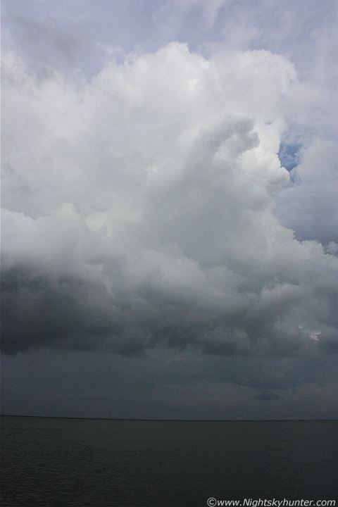 |
Vertical shot of the S tower on the edge of the precip area, it may have gone up on the outflow at that time. Here it is at wide angle in relation to the Lough.
 |
Camera panned more to the L (N) at the inflow/outflow interface at the mid section of the storm where several more tall towers can be seen merged together. There was amazing convergence taking place rite before our eyes, that mid level cloud was racing in towards the storm from behind us (W) and joining the storm, it was amazing to see this happen in real time with the naked eye. We were extremely busy at this stage taking images and video, constantly shooting various areas of interest, since it wouldn't fit in the frame we had no choice but to take image 'slices', I should have actually merged several still images together for a full scale storm structure shot. The sky was actually darker than this in reality, especially the region over the water which looked like a nasty place to be. More on page 2.
Martin McKenna